![]() Connecting the Des Plaines River Trail
Connecting the Des Plaines River Trail
The Active Transportation Alliance and Civiltech Engineering, on behalf of Cook County, studied the feasibility of connecting a 2.5 mile gap of the Des Plaines River Trail (DPRT) between the CTA Forest Park Blue Line station (Forest Park), Illinois Prairie Path (Maywood) and the Salt Creek Trail near 26th Street (North Riverside).
The DPRT Central Feasibility Study kicked-off in the spring of 2022 and received funding through the Invest in Cook Program.
The project team hosted an Public Open House on April 18, 2023 at Proviso East High School in Maywood to provide the public an opportunity to comment on the proposed trail alignments.
A webinar about the Des Plaines River Trail system with status updates of several ongoing studies was held in May 2023. You can watch the webinar recording here.
The final report of recommended trail alignments was published November 2023. In 2025, Cook County received $800,000 in STP-Local funding to begin preliminary engineering for this segment of the trail.
If you have any questions, you can email Alex Perez at [email protected].
 Project Overview
Completing the Des Plaines River Trail is a high priority for our region and has been the focus of several recent studies. If the collective visions are realized, the trail would run continuously to the Wisconsin border, connecting to the Salt Creek Trail and the Illinois Prairie Path, through some of Cook County’s most densely populated communities and key destinations.
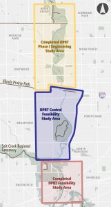
Standing in the way of a complete trail is a gap that spans about 2.5-miles between the Forest Park Blue Line station at Van Buren Street and 26th Street (shown in blue on the map to the left). Trail users wishing to connect to and from communities to the south must currently travel along high-volume arterials or wind through disconnected residential streets. It is, therefore, necessary to create a clear, identifiable, low-stress, on-street option to fill in the gap.
Update:
- Cook County Department of Transportation and Highways (CCDOTH) received $800,000 in STP-local funding in 2025 for preliminary engineering of the Central Des Plaines River Trail.
Other On-Going Studies & Current Status
North Trail Improvements: The Forest Preserves of Cook County is currently working on several engineering studies and projects along the 10-mile segment of the Des Plaines Trail System from North Avenue to Touhy Avenue to improve trail user experience and enhance safety. This improvement area is indicated in yellow on the map above.
Current Status:
- Segments 1, 2 and 3 (Touhy Ave to Lawrence Ave) – completed including bridge over Lawrence Ave.
- Segment 4 (Lawrence Ave to Irving Park Rd) – construction finishing by end of 2025/early 2026
- Segment 5 through 10 (Irving Park Rd to North Ave) – phase I engineering studies underway, Fullerton Ave to North Ave construction expected to begin Fall 2026 or Spring 2027
News updates:
- Des Plaines Trail to run through River Forest (Wednesday Journal, April 2024)
-
Des Plaines River Trail update by Irving Park Road: Work to come this and next year (Suburbanchicagobicycling.com, September 2025)
South Extension Planning Study: The Chicago Metropolitan Agency for Planning (CMAP) led a 2019 planning study to focus on closing the trail gap of the southern-most segment of the Des Plaines River Trail between W. 26th St and Ogden Ave. This study area is shown in red on the map above.
Current Status:
- The Village of Brookfield is working with Cook County and other groups to move Phase 1 of the project forward (January 2024 update, Riverside-Brookfield Landmark)
- Riverside wavers on Des Plaines River Trail extension (October 2025 update, Riverside-Brookfield Landmark)
Community Feedback
 In order to gather direct input about the Des Plaines River Trail Central Feasibility, Active Trans conducted a community survey and stakeholder interviews with each village, transit and government agencies, medical centers, advocates, and elected officials. In total, over 300 community members took the survey. The project team also attended Party for the Preserves in Miller Meadow and the annual Tour de Proviso bike ride to seek additional input from the public.
The survey and interviews focused on understanding general community benefits of the proposed trail, desired routes and amenities, concerns about the area, and barriers that might prevent people from accessing or using the trail including difficult crossings.
In general, we heard a great deal of excitement about the project, particularly over improved access to destinations and nature that a safe walking and biking route could provide.
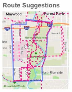
Proposed Trail Alignments
Four alignments shown below were considered as part of the study. Each alignment is a combination of both low-stress on-street routes and side paths. Unfortunately, an off-street trail along the entirety of the river was determined to be infeasible due to major challenges with flooding and property ownership.
- Yellow alignment (Miller Meadow): Illinois Prairie Path to 9th Avenue to Roosevelt Road through Miller Meadow to Cermak Road, 5th Avenue, and then 26th Street. Note: Miller Meadow does not officially allow 24-hour access.
- Magenta alignment (Medical Campus): Illinois Prairie Path to 9th Avenue to Roosevelt Road through the Medical Campus (at Frontage Road and 2nd Avenue) to Cermak Road, 5th Avenue and then 26th Street. Note: This alignment is no longer considered feasible out of concern that it would create conflicts with emergency vehicles.
- Green alignment (Des Plaines Avenue): Road diet along Des Plaines Avenue from Forest Park CTA Blue Line Station to 26th Street. This option could involve a side path or on-road bikeway, however, property would need to be acquired. This alignment is the most expensive and complicated option and does not connect to Miller Meadow.
- Blue alignment (Local Routes): Illinois Prairie Path to 9th Avenue to 14th Street (planned on-street bike route) to 25th Avenue (planned side path) to the Salt Creek Trail.
Project Documents
Final DPRT Central Feasibility Study
DPRT Central Feasibility Study Existing Conditions Report
Contacts
Alex Perez, Active Transportation Alliance, [email protected]
Maggie Czerwinski, Active Transportation Alliance, [email protected]
Thank you to our Partners!
A big thank you to the following agencies, elected officials, and community members who helped shape this study and who are keeping it moving forward:
- Village of Broadview
- Village of Brookfield
- Village of Forest Park
- Village of Maywood
- Village of North Riverside
- Chicago Transit Authority
- PACE Bus
- Cook County Commissioners
- Cook County Department of Transportation and Highways
- Cook County Forest Preserve
- Illinois Circuit Court of Cook County
- Metropolitan Water Reclamation District (MWRD)
- Illinois Department of Transportation
- Loyola Medical District
- Hines VA
- Openlands
- Illinois Prairie Path NP
- Friends of the Forest Preserve
- Brookfield Zoo
- Local Advocates