The Old Plank Road Trail (OPRT) extension project will bring a much-needed trail connection to the Chicago Southland, connecting Illinois and Indiana through a vibrant new recreational pathway.
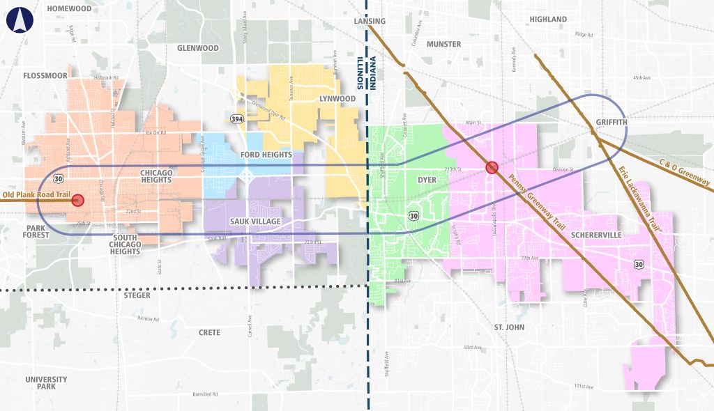
This initiative aims to convert an inactive rail line into a multi-use trail, linking the existing OPRT in Chicago Heights, Illinois, with the Pennsy Greenway in Schererville, Indiana.
The Old Plank Road Trail is a 22-mile-long rail trail in Cook County and Will County. It stretches east-west between Chicago Heights and Joliet, serving suburbs such as Frankfort and New Lenox. Completed in the late 1980s, the OPRT is one of the oldest and most loved rail trails in the Chicago region.
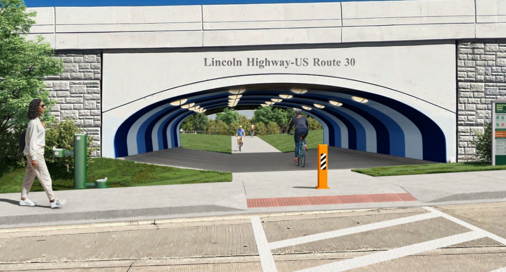
The extension project would add roughly ten miles of new trail mileage — combined with some preferred street routes — to the eastern end of the trail. Phase 1 engineering for the trail extension is expected to launch in the coming year or so.
FROM VISION TO REALITY
The OPRT Extension Feasibility Study, which began in spring 2022 with funding from the Invest in Cook Program, has recently wrapped up its work after a series of public engagement events and many conversations with local municipalities.
The final report, published in January 2025, focused on finding the best route to connect the eastern end of the OPRT at the Thorn Creek Trail in Chicago Heights, Illinois, to the Pennsy Greenway in Schererville, Indiana.
The result? A preferred trail alignment that’s ready for the next stages of development.
A COLLABORATIVE EFFORT
This project isn’t just about building a trail – it’s about building communities. The study brought together:
- Six municipalities: Chicago Heights, Ford Heights, Sauk Village, Lynwood, Dyer, and Schererville
- Regional planning organizations
- County and forest preserve authorities
- Non-profit groups
The proposed trail extension spans these six municipalities, with plans to repurpose an inactive Norfolk Southern rail line at its core.
The study also explored bike route connections to link the OPRT extension with local community hotspots.
COMMUNITY AT THE HEART
Public input has been crucial in shaping a trail extension that will serve not only local community members but also regional trail users.
Active Transportation Alliance has been a key player in reaching out to local communities about the trail extension. We helped host three open houses in local communities to hear ideas on the potential trail alignment and trail improvements.
We also participated in a video project interviewing local business people and government officials about extending the OPRT into their communities. See the video above as well as “Voices from the Trail” interviews with Schererville, Indiana, Parks Superintendent John Novacich; Ford Heights Park District Commissioner Kimberly Griffin; Clark Williams, owner of Clark Cycle in Chicago Heights; and Tom Schmidt, president of Schererville, Indiana, Town Council.
The project team heard from residents through a number of venues:
- An interactive online map and public survey
- Pop-up meetings at community events
- Focus groups and open houses
This collaborative approach ensures that the trail will provide maximum benefit to those who will use it most.
LOOKING TO THE FUTURE
While we’re expecting the OPRT extension to be a great recreational amenity as well as a transportation route, it’s also a step towards:
- Safer, more active communities
- Increased connectivity between neighborhoods
- Potential for trail-oriented development
- A healthier, more vibrant Chicago Southland
As the project moves forward, it promises to be a game-changer for the region, offering new opportunities for recreation, transportation, and community connection. Stay tuned for updates as this exciting project progresses.
Want to learn more about the project? Here’s the full trail extension study report, as well as reports on existing conditions and potential corridor designs.