An expanded and more connected trail system is taking shape in the south suburbs.
We recently hosted a webinar that explored how the Cal-Sag Trail, Old Plank Road Trail, Illinois & Michigan Canal Trail, and Centennial Trail are improving their connectivity — expanding opportunities for nearby communities to reap the benefits of recreation, healthy lifestyles, and economic development.
Here’s what we learned.
CAL-SAG TRAIL
Built almost entirely along the banks of the Cal-Sag Channel and the Calumet River, the Cal-Sag Trail stretches from Lemont in the west to Burnham in the east near the Indiana border. While most of the Cal-Sag trail is up and running, two segments are still incomplete.
One unfinished section is located between Cicero Avenue in Alsip and Francisco Street in Blue Island.
In particular, the area between Freedom Park and Pulaski Road has been held up for the last six or seven years as the Alsip Park District and Cook County Department of Transportation and Highways negotiate with the railroad companies to ensure safe crossings across the railroad tracks in that area.
“They’ve made progress and hope that they can go to construction letting late this fall,” said Steve Buchtel, president of the Friends of the Cal-Sag Trail. “If you’ve been following the Cal-Sag Trail development, you will see a list of blown build dates dating back all the way to 2014. So knock on wood, but this is the best news we’ve had about getting that segment constructed between Cicero and Pulaski.”
The eastern segment of the trail in Dolton is also incomplete. Because there was an alignment change to mitigate wetland concerns in the area, it triggered the need for additional environmental surveys.
To pay for the engineering firm to conduct those surveys, South Suburban Mayors and Managers Association obtained federal funding and Cook County Department of Transportation and Highways provided the local matching funds. Once the surveys are complete and the Illinois Department of Transportation accepts those reports, Buchtel estimates construction letting will commence in late 2024.
In the meantime, IDOT is moving forward with the construction of the Halsted Street Bridge between Blue Island and Riverdale. “Halsted Street is a lot of truck traffic. It’s a big arterial road that goes over rail yards,” Buchtel said. “So, we’re excited there’s movement on that as well.”
When completed, the 26-mile multiuse trail will connect to regional trails, bus and rail transit systems, retail areas, parks, forest and nature preserves, marinas, and golf courses. About 185,000 residents in 14 nearby communities live within a mile of the Cal-Sag trail, while more than 1.2 million people live within a 15-minute drive of the trail.
OLD PLANK ROAD TRAIL
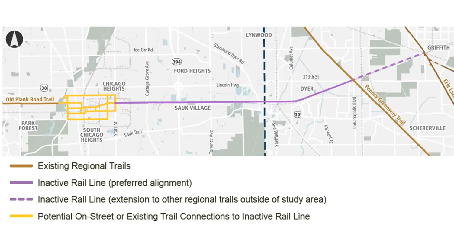
Update: As of Feb, 2024, the Old Plank Road Trail will be extended not just to the Pennsy Greenway, but also further east to the Erie Lackawanna Trail. Active Transportation Alliance has been assisting with the public input process for the this project, and we were glad to share at a recent open house in Schererville the preliminary plan for connecting the trail extension to the Erie Lackawanna Trail.
The Old Plank Road Trail — which runs 22 miles from Joliet through New Lenox, Frankfort, Matteson, Park Forest, and Chicago Heights — will be getting about 10 miles longer in the future, extending east into Indiana.
Sauk Village, the Northwestern Indiana Regional Planning Commission, South Suburban Mayors and Managers Association, and Cook County Department of Transportation and Highways conducted a feasibility study to assess extending the trail east from Chicago Heights to the Pennsy Greenway Trail in Schererville, Indiana.
Most of the extension would take place along the inactive Norfolk Southern rail line. The extension will include trail elements such as connections to communities and mass transit, street alignments, bike lanes, sidewalks, pocket parks and art projects.
During the webinar, Jacque Henrikson, senior transportation planner for Civiltech Engineering, a consultant for the feasibility study, showed several renderings of how the extension could improve sustainable transportation and community development while spurring trail-oriented economic development.
For example, one of the renderings depicted the enhancements the trail would bring along 16th Street in Chicago Heights. It featured buffered bike lanes, widened sidewalks, wayfinding signage, and connections to the Pace buses.
Another rendering showed how the extension would make use of a previously built U.S. Route 30 underpass in Lynwood. The underpass would have trail amenities, such as air pumps for bike tires, water fountains, enhanced lighting, cohesive signage, and public art.
The project received funding from the Transportation Alternatives Program for engineering and implementation this year. But the project team is also hosting public meetings with communities along the extension to gain their residents’ input as the project moves forward.
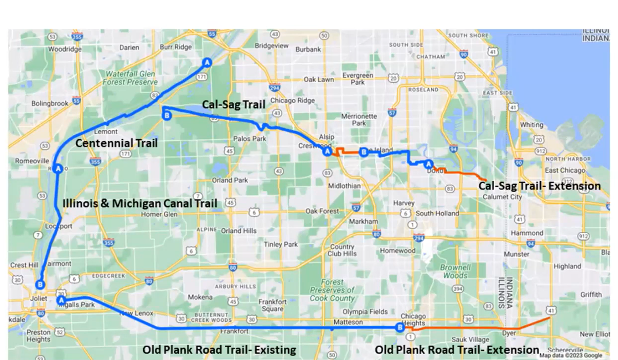
ILLINOIS & MICHIGAN CANAL TRAIL AND CENTENNIAL TRAIL CONNECTION
A new bike path will connect the I&M Canal Trail and the Centennial Trail next spring, thanks to a first-of-its kind public-private partnership among the CITGO Lemont Petroleum Refinery, Romeoville, Lockport, Lemont, and Will County Forest Preserve.
The CITGO Refinery decided to get involve with the project after recognizing that cyclists from nearby Romeoville, Lockport, and Lemont couldn’t safely bike around Romeo Road, where its refinery is located.
The refinery, Romeoville, Lockport, Lemont, and Will County Forest Preserve have spent the last four years working on the bike trail on Romeo Road, connecting the Centennial Trail from the north and the I&M Trail from the south.
The east-west bike path will also extend east past the two trails toward the refinery and connect to the Romeoville Metra Station. Amenities will include guardrails, protected bike lanes, reflective bollards, a bike repair station, a bike mural, directional signage, a kiosk with information about the trail, and landscaping.
A groundbreaking ceremony for the trail connection that linking the 13-mile Centennial Trail and the 11-mile I&M Canal Trail took place in mid-July.
“I think it’s really important for our region to connect Joliet, Lockport, Romeoville, and Lemont,” said Lockport Mayor Steven Streit. “It’s such a great connection with the I&M Canal Trail and one of the confusing points on the trail has been this very spot. I’ve actually seen people come down here and do circles and ask ‘Do you know where the trail picks up?’ I’m really excited about working with Romeoville, CITGO, and the forest preserve to get better wayfinding and to help make the corridor stronger.”
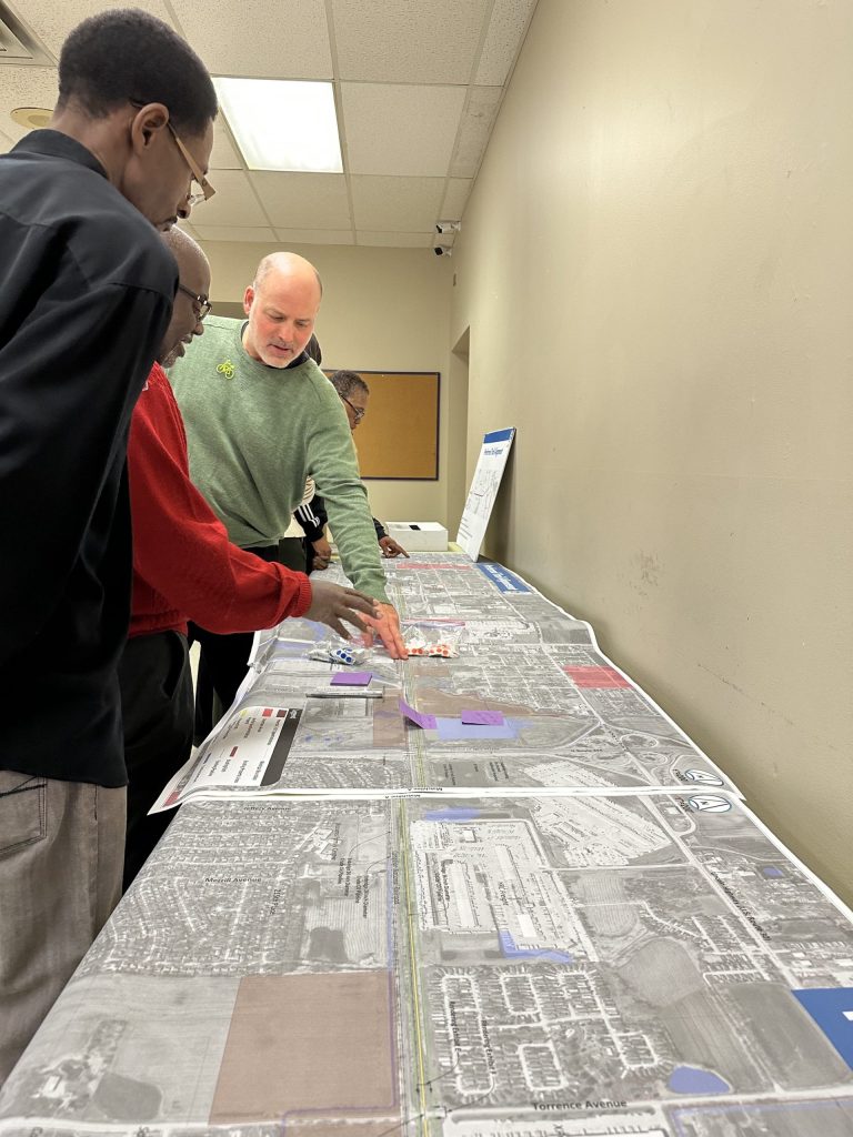
Top photo is from a recent public meeting about the proposal for extending the Old Plank Road Trail. For more information about the three trail projects described here, watch entire webinar: